
Metrovalencia map
The ten lines, their 144 stations and stops and the fare zones.
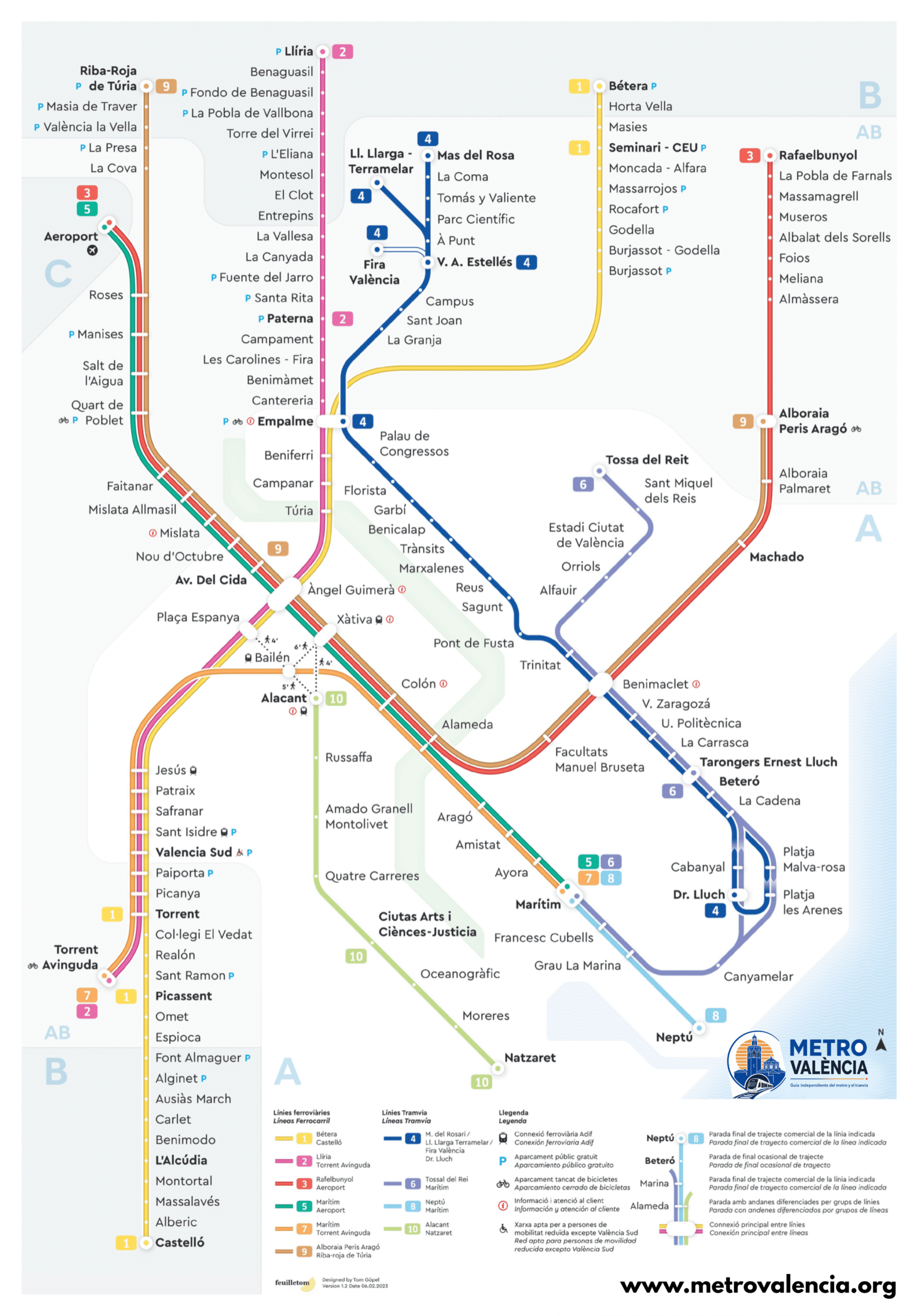
The map as a PDF
Metrovalencia map · PDF
The map at full size, ready to print on A3 or to keep on your phone for when there is no signal.
Where this map comes from
It is a map designed by Tom Göpel (feuilletom) for this site; his signature is printed on the map itself, bottom left. It is not FGV’s map retouched, nor a copy of it.
What we did do is check it: the names of the 144 stations were compared, one by one, against the official GTFS of Ferrocarrils de la Generalitat Valenciana. That comparison turned up ten labels that do not match the official name — among them «Mas del Rosa» for Mas del Rosari and «Tossa del Reit» for Tossal del Rei. We have not retouched them on the image, because patching a PNG leaves marks and creates a third version nobody can tell apart; they are written down to be fixed in the design instead. The names on this site — the station pages, the route planner and the lists — come from the official data, not from the map, so none of them is wrong.
Two things that help you read it. North is up: the sea is east, the airport west and Bétera north-west. And the distances are not to scale: it is 44 km in a straight line from Àngel Guimerà to Castelló, and drawn to scale half the sheet would be fourteen lonely stops and the city of València an unreadable blob.
FGV’s fare-zone map, which is a different thing, is their work and is not reproduced here.
The lines at a glance
| Line | Type | Stations/stops | Route |
|---|---|---|---|
| L1 | Metro | 40 | Castelló – Bétera |
| L2 | Metro | 34 | Torrent Avinguda – Llíria |
| L3 | Metro | 27 | Aeroport – Rafelbunyol |
| L4 | Tram | 33 | Dr. Lluch – Mas del Rosari |
| L5 | Metro | 18 | Aeroport – Marítim |
| L6 | Tram | 21 | Marítim – Tossal del Rei |
| L7 | Metro | 16 | Torrent Avinguda – Marítim |
| L8 | Tram | 4 | Marítim – Neptú |
| L9 | Metro | 23 | Riba-roja de Túria – Alboraia Peris Aragó |
| L10 | Tram | 8 | Alacant – Natzaret |
Interchanges are counted on every line they belong to: that is why the column adds up to 224 and not 144.
144 stations or 148: why there are two figures
FGV publishes 148 stations and halts. We count 144. Both figures are right, and the operator itself explains the difference in a footnote on its facts-and-figures page: “for the station count, À. Guimerà, Empalme, Marítim and Benimaclet are considered as two network installations; they have two separate numbers associated with different platforms”. That is four stations counted twice, and 144 + 4 = 148. It adds up exactly.
For passengers, each of those four is a single station: you change line without going out or validating again. That is why each one has a single page here: Àngel Guimerà, Empalme, Marítim and Benimaclet.
The fare zones on the map
On the Metrovalencia network there are only three cases: zone A (61 stations and stops, the city core and the seafront), the A-B overlap (58), which is not a third zone but the band where A and B overlap and whose stations belong to both, and zone B (24), the outer branches. Separately there is the “+” area, with a single station: Aeroport.
Whether a station is in the overlap matters: a journey from there to the centre counts as one zone, not two. The zones C and D you will see on the integrated tickets belong to MetroBus and Renfe Cercanías (commuter rail), not to Metrovalencia. Every station page gives its zone, and the fares are on tickets and cards.
The beach loop
What no schematic map makes clear: at the beach the tracks form a one-way loop, and three stops are served in one direction only.
The one-way beach loop
Trams always run round this ring in the same direction and come back to where they started; there is no service in the opposite direction.
Cabanyal is served only in the direction Dr. Lluch → La Cadena. Platja Malva-rosa and Platja les Arenes only in the opposite direction, after leaving La Cadena. To get from Cabanyal to either of the two Platja stops you have to go all the way round the loop.